Node types
All node types of the geo data addon start with the prefix sophora-geodata.
| Node type | Explanation |
|---|---|
sophora-geodata-mix:geoDataMap | This is the mixin for map documents. Just add this to an existing node type to receive a fully supported map document type. The mixin will bring along all supported configuration parameters for maps as well as a geo data table. You'll just have to configure them on a visible tab in your node type. See the section on provider configuration for important details on related properties. |
sophora-geodata-nt:geoLibrary | This is the node type for geo data libraries which can be used to create and manage reusable geo information. |
sophora-geodata-nt:pinSet | This is the node type for all selectable layout groups of pins. |
sophora-geodata-nt:pinSetTableData | This is the child node type for rows of the dynamic table used in sophora-geodata-nt:pinSet. |
sophora-geodata-nt:shapeLayout | This is the node type for all selectable layout groups of shapes. |
sophora-geodata-nt:shapeLayoutTableData | This is the child node type for rows of the dynamic table used in sophora-geodata-nt:shapeLayout. |
Details on the provider configuration
The configurations for the property sophora-geodata:initialMapView and the child node sophora-geodata:geoData both come with the optional (map) provider configuration. The configuration has to be written in JSON-Format and is exactly the same as for the provider configuration properties from the Maps-Addon. This is explained in detail as part of its input field configuration.
We recommend to use the same provider configuration for inivialView and geoData. If this is the case then the selected initial view will also be applied when setting points or line strings as cell values for the Geodata table. This will not change the values of the cells but is more convenient for the editor.
This requires DeskClients in version 2.5.21, 2.6.0 or never.
For downward compatibility reasons, the GeoData Delivery will use Bing as fall back if no provider is configured explicitly.
Select values
| Select value document name | Select value document external id | Explanation |
|---|---|---|
| Pin sets | geoDataPinSets | This select value document stores all selectable layout groups for pins. |
| Area layouts | geoDataShapeLayouts | This select value document stores all selectable layout groups for area. |
| Line string layouts | geoDataLineStringLayouts | This select value document stores all selectable layout groups for line strings. |
| Line styles | geoDataLineStyleSelectValue | This select value document stores all selectable line styles that can be used as the border of areas or the drawing style of line strings. |
| Cluster factor | clusterFactorSelectValues | This select value document stores all selectable cluster factors that control how tight clustering is performed. |
Layouts
Layouts can be used to give pins and areas a different appearance.
A layout group contains several layouts to differentiate pins and areas regarding a criterion.
Example: The geo data table uses a criterion with 3 different states 'low', 'medium' and 'high'. So you will have to create a layout group with 3 layouts. These layouts will then visually separate 3 pins or areas which match the different states.
Creation process
The following explanation will describe the creation of a layout group for pins.
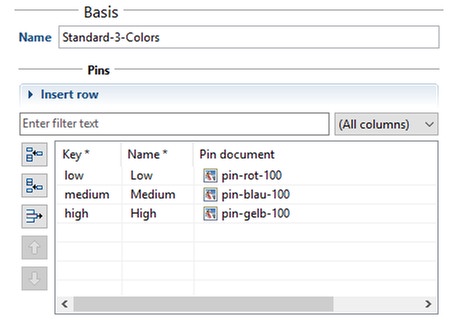
First of all you need a pin set document which contains the images for the pins.
The pin set document contains a dynamic table where you will have to add one row for each pin that should be selectable. Each row contains a unique key which is used as an identifier internally, a name that provides a user readable label for the pin and a reference to the image document which contains the actual pin.

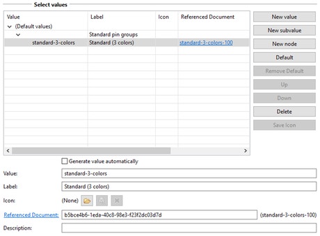
A layout group can be created by adding a new entry to the appropriate layout select value document ("Pin sets" or "Area layouts"). The layout group needs a label to be selectable and distinguishable in the column configuration of the geo data table. Besides a label the new entry also needs a value and a reference to the pin set document you created above.

After following these steps, your new pin set is selectable in the column configuration of a column of type "Geo point". After chosing the pin set, the entries of the pin set document are selectable in the row edit form above the geo data table.
Further configuration
The geo data addon will come with a configuration document holding further parameters for maps. It can be found in the administration view under System > Configuration > geodata >GeoDataConfiguration.
The listed values are the system default - they will be applied with the exact same values even if the entries are removed from the configuration document.
| Key | Default value | Explanation |
|---|---|---|
| ClusterFontColor | 255,255,255 | RGB-code of the color of cluster point labels |
| ClusterFontsize | 16 | Font size of cluster point labels |
| ClusterFontType | Arial | Font type of cluster point labels |
| ClusterRadius | 22 | Radius of circles for cluster points, should be slightly bigger than ClusterFontSize |
| ClusterStrokeColor | 255,255,255 | RGB-code of the color of cluster points |
| DateFormat | yyyy-MM-dd HH:mm | Format string for printing values from columns of type Date |
| Locale | de | Locale format for printing various none-string values, e.g. numbers |
| SearchTextPlaceholder | In der Karte suchen... | On the delivery side a map might come with a search slot (This is part of every maps configuration). The property SearchTextPlaceholder configures the placeholder for the search input field. |